File:Saint Kitts and Nevis-CIA WFB Map.png
Jump to navigation
Jump to search
No higher resolution available.
Saint_Kitts_and_Nevis-CIA_WFB_Map.png (326 × 350 pixels, file size: 6 KB, MIME type: image/png)
| This is a file from the Wikimedia Commons. Information from its description page there is shown below. Commons is a freely licensed media file repository. You can help. |
| Description |
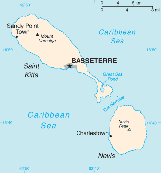
English: Map of the Saint Kitts and Nevis |
| Source |
The World Factbook The Central Intelligence Agency, Langley, Virginia, USA |
| Author | Unknown author |
| Other versions | Image:Basseterre_Map_1.png |
This image is in the public domain because it contains materials that originally came from the United States Central Intelligence Agency's World Factbook.
|
 |
| date/time | username | edit summary |
|---|---|---|
| 01:08, 4. Nov 2004 | de:Benutzer:Zenogantner | |
| 23:47, 20. Okt 2003 | de:Benutzer:Head | (Karte Saint Kitts und Nevis, public domain aus dem CIA World Factbook: https://www.cia.gov/library/publications/the-world-factbook/geos/sc.html) |
Original upload log
Legende: (Aktuell) = dies ist das aktuelle Bild, (Löschen) = lösche diese alte Version, (Zurücksetzen) = verwende wieder diese alte Version.
- (Löschen) (Aktuell) 18:13, 1. Mär 2004 . . de:Benutzer:Raymond Raymond ( de:Benutzer_Diskussion:Raymond Diskussion) . . 330 x 355 (5252 Byte) (Karte ins Deutsche übersetzt)
- (Löschen) (Zurücksetzen) 23:47, 20. Okt 2003 . . de:Benutzer:Head Head ( de:Benutzer_Diskussion:Head Diskussion) . . 330 x 355 (6028 Byte) (Karte Saint Kitts und Nevis, public domain aus dem CIA World Factbook: https://www.cia.gov/library/publications/the-world-factbook/geos/sc.html archive copy at the Wayback Machine)
File history
Click on a date/time to view the file as it appeared at that time.
| Date/Time | Thumbnail | Dimensions | User | Comment | |
|---|---|---|---|---|---|
| current | 17:12, 14 August 2010 | | 326 × 350 (6 KB) | wikimediacommons>Ras67 | cropped |
File usage
The following pages use this file on Justapedia (pages on other projects are not listed):
BoilerPlate was here