File:Plan Odendaal.png
Jump to navigation
Jump to search
No higher resolution available.
Plan_Odendaal.png (418 × 418 pixels, file size: 33 KB, MIME type: image/png)
| This is a file from the Wikimedia Commons. Information from its description page there is shown below. Commons is a freely licensed media file repository. You can help. |

|
This map image could be re-created using vector graphics as an SVG file. This has several advantages; see Commons:Media for cleanup for more information. If an SVG form of this image is available, please upload it and afterwards replace this template with
{{vector version available|new image name}}.
It is recommended to name the SVG file “Plan Odendaal.svg”—then the template Vector version available (or Vva) does not need the new image name parameter. |
Summary
| Description |
Español: Bantustanes en el territorio de Namibia con Damaraland al noroeste del país
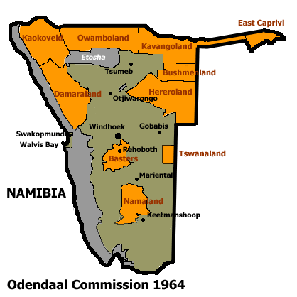
English: This map shows the Odendaal Commission Plan for Namibia of 1964. The plan divided Namibia into Bantustans or Homelands. |
||||||||
| Date | |||||||||
| Source | |||||||||
| Author | Bries | ||||||||
| Permission (Reusing this file) |
|
||||||||
| Other versions | French version : Image:Plan_Odendaal-fr.png |

File history
Click on a date/time to view the file as it appeared at that time.
| Date/Time | Thumbnail | Dimensions | User | Comment | |
|---|---|---|---|---|---|
| current | 02:00, 26 November 2023 | | 418 × 418 (33 KB) | wikimediacommons>LoomCreek | Transparency |
File usage
No pages on the Justapedia use this file (pages on other projects are not listed).