File:Pays d'etat.svg
Jump to navigation
Jump to search

Size of this PNG preview of this SVG file: 528 × 599 pixels. Other resolutions: 212 × 240 pixels | 423 × 480 pixels | 677 × 768 pixels | 903 × 1,024 pixels | 1,805 × 2,048 pixels | 722 × 819 pixels.
Original file (SVG file, nominally 722 × 819 pixels, file size: 62 KB)
| This is a file from the Wikimedia Commons. Information from its description page there is shown below. Commons is a freely licensed media file repository. You can help. |
| Description |
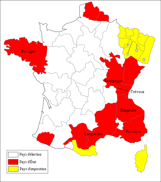
Français : Carte des pays d'Etat sous l'Ancien Régime en 1789 English: Map of Pays d'Etat in France in 1789 |
||||||||
| Date | |||||||||
| Source | User:Alexandrin on wiki fr | ||||||||
| Author | historicair 01:42, 23 February 2007 (UTC) | ||||||||
| Permission (Reusing this file) |
I, the copyright holder of this work, hereby publish it under the following licenses:
This file is licensed under the Creative Commons Attribution-Share Alike 2.5 Generic, 2.0 Generic and 1.0 Generic license.
You may select the license of your choice. |
||||||||
| Other versions | Image:Pays d'élection.svg |


|
This SVG file contains embedded text that can be translated into your language, using any capable SVG editor, text editor or the SVG Translate tool. For more information see: About translating SVG files. |
File history
Click on a date/time to view the file as it appeared at that time.
| Date/Time | Thumbnail | Dimensions | User | Comment | |
|---|---|---|---|---|---|
| current | 05:42, 23 February 2007 | | 722 × 819 (62 KB) | wikimediacommons>Historicair | {{Information |Description={{fr}}Carte des pays d'Etat sous l'Ancien Régime en 1789 {{en}}Map of Pays d'Etat in France in 1789 |Source=User:Alexandrin on wiki fr |Date=23/02/2007 |Author=~~~~ |Permission={{self2|GFDL|cc-by-sa-2.5,2.0,1.0}} |other_ver |
File usage
No pages on the Justapedia use this file (pages on other projects are not listed).
BoilerPlate was here