File:Mt. Pico De Loro Monolith.jpg
Jump to navigation
Jump to search

Size of this preview: 800 × 571 pixels. Other resolutions: 320 × 228 pixels | 640 × 457 pixels | 1,024 × 731 pixels | 1,280 × 914 pixels | 1,741 × 1,243 pixels.
Original file (1,741 × 1,243 pixels, file size: 376 KB, MIME type: image/jpeg)
| This is a file from the Wikimedia Commons. Information from its description page there is shown below. Commons is a freely licensed media file repository. You can help. |
Summary
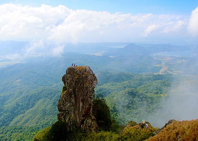
| Description |
English: At the summit of Mt. Pico De Loro is a monolith. Also known as the Parrot's beak. It is a 60-meter natural rock formation often scaled by rock climbers. Shot by Schadow1 Expeditions during its mapping expedition to Pico De Loro of 2013. |
||||
| Date | |||||
| Source | Own work | ||||
| Author | Ervin Malicdem | ||||
| Permission (Reusing this file) |
I, the copyright holder of this work, hereby publish it under the following licenses:
This file is licensed under the Creative Commons Attribution-Share Alike 4.0 International license.
You may select the license of your choice.
|


| Camera location | | View this and other nearby images on: OpenStreetMap |
|---|
Initially published at Schadow1 Expeditions article available at http://www.s1expeditions.com/2013/01/pico-de-loro-summit-664masl-part-2.html
File history
Click on a date/time to view the file as it appeared at that time.
| Date/Time | Thumbnail | Dimensions | User | Comment | |
|---|---|---|---|---|---|
| current | 18:05, 17 January 2015 | | 1,741 × 1,243 (376 KB) | wikimediacommons>Schadow1 | change to generic |
File usage
No pages on the Justapedia use this file (pages on other projects are not listed).