File:Map of Cumberland Co., New Jersey - from actual surveys LOC 2010592714.jpg
Jump to navigation
Jump to search

Size of this preview: 551 × 600 pixels. Other resolutions: 220 × 240 pixels | 441 × 480 pixels | 705 × 768 pixels | 940 × 1,024 pixels | 1,881 × 2,048 pixels | 16,806 × 18,300 pixels.
Original file (16,806 × 18,300 pixels, file size: 30.53 MB, MIME type: image/jpeg)
| This is a file from the Wikimedia Commons. Information from its description page there is shown below. Commons is a freely licensed media file repository. You can help. |
Summary
| Warning | The original file is very high-resolution. It might not load properly or could cause your browser to freeze when opened at full size. |
|---|
| Description |
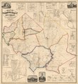
English: Relief shown by hachures. Cadastral map showing land ownership. LC Land ownership maps, 445 Available also through the Library of Congress Web site as a raster image. Includes ill., table of distances, "Bridgeton business directory", and 19 insets of town plans showing property owners. |
||
| Title | Map of Cumberland Co., New Jersey : from actual surveys | ||
| Shelf ID | G3813.C8 1862 .M3 G3813.C8 1862 .M3 G3813.C8 1862 .M3 | ||
| Date | |||
| Source | https://www.loc.gov/item/2010592714/ | ||
| Author | Beers, F. W. (Frederick W.); A. Pomeroy & Co.; Warner, C. S. (Charles S.); Beers, S. N.; Lake, L. | ||
| Permission (Reusing this file) |
|
||
| Other versions |
|
||
| Location | New Jersey · United States · Cumberland County | ||
| Part of | American Memory · Catalog · County Landownership Maps · Geography And Map Division · Cultural Landscapes | ||
| Subject | Cumberland County (N.J.) · Cumberland County · New Jersey · United States · Maps · Real Property |

Licensing
|
This is a faithful photographic reproduction of a two-dimensional, public domain work of art. The work of art itself is in the public domain for the following reason:
The official position taken by the Wikimedia Foundation is that "faithful reproductions of two-dimensional public domain works of art are public domain".
This photographic reproduction is therefore also considered to be in the public domain in the United States. In other jurisdictions, re-use of this content may be restricted; see Reuse of PD-Art photographs for details. | ||||
File history
Click on a date/time to view the file as it appeared at that time.
| Date/Time | Thumbnail | Dimensions | User | Comment | |
|---|---|---|---|---|---|
| current | 09:00, 1 May 2020 | | 16,806 × 18,300 (30.53 MB) | wikimediacommons>Fæ | LOC Maps https://www.loc.gov/item/2010592714/ #6527 |
File usage
No pages on the Justapedia use this file (pages on other projects are not listed).