File:Map highlighting Athens Township, Jewell County, Kansas.svg
Jump to navigation
Jump to search

Size of this PNG preview of this SVG file: 600 × 600 pixels. Other resolutions: 240 × 240 pixels | 480 × 480 pixels | 768 × 768 pixels | 1,024 × 1,024 pixels | 2,048 × 2,048 pixels.
Original file (SVG file, nominally 768 × 768 pixels, file size: 25 KB)
| This is a file from the Wikimedia Commons. Information from its description page there is shown below. Commons is a freely licensed media file repository. You can help. |
File history
Click on a date/time to view the file as it appeared at that time.
| Date/Time | Thumbnail | Dimensions | User | Comment | |
|---|---|---|---|---|---|
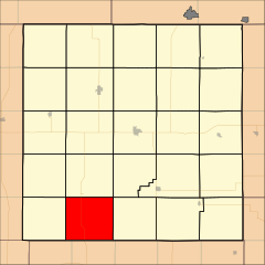
| current | 23:52, 25 March 2008 | | 768 × 768 (25 KB) | wikimediacommons>File Upload Bot (Omnedon) | == Summary == {{Information |Description={{en|This is a map of Jewell County, Kansas, USA which highlights the location of Athens Township.}} |Source=My own work, using freely-available TIGER data and custom-written MapScript applications |Date=2008-03-2 |
File usage
No pages on the Justapedia use this file (pages on other projects are not listed).