File:MajorVolcanoesOfThePhilippines-USGS.gif
Jump to navigation
Jump to search
No higher resolution available.
MajorVolcanoesOfThePhilippines-USGS.gif (336 × 594 pixels, file size: 18 KB, MIME type: image/gif)
| This is a file from the Wikimedia Commons. Information from its description page there is shown below. Commons is a freely licensed media file repository. You can help. |
Summary
| Description |
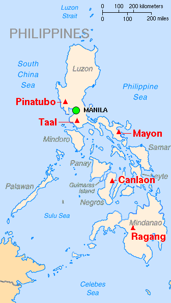
English: Map showing major volcanoes of the Philippines.
Français : Carte des principaux volcans aux Philippines |
| Date | |
| Source | Archived source link |
| Author | Lyn Topinka, base map from CIA, volcanoes from Simkin and Siebert |
| Other versions |
|

Licensing
This image is in the public domain in the United States because it only contains materials that originally came from the United States Geological Survey, an agency of the United States Department of the Interior. For more information, see the official USGS copyright policy.
|
File history
Click on a date/time to view the file as it appeared at that time.
| Date/Time | Thumbnail | Dimensions | User | Comment | |
|---|---|---|---|---|---|
| current | 17:10, 16 February 2014 | | 336 × 594 (18 KB) | wikimediacommons>Hike395 | Crop title, logo, credit line |
File usage
The following pages use this file on Justapedia (pages on other projects are not listed):