File:Lasvegas.terra.1500pix.jpg
Jump to navigation
Jump to search
Size of this preview: 716 × 600 pixels. Other resolutions: 287 × 240 pixels | 573 × 480 pixels | 917 × 768 pixels | 1,223 × 1,024 pixels | 1,500 × 1,256 pixels.
Original file (1,500 × 1,256 pixels, file size: 199 KB, MIME type: image/jpeg)
| This is a file from the Wikimedia Commons. Information from its description page there is shown below. Commons is a freely licensed media file repository. You can help. |

|
This file was moved to Wikimedia Commons from en.wikipedia using a bot script. All source information is still present. It requires review. Additionally, there may be errors in any or all of the information fields; information on this file should not be considered reliable and the file should not be used until it has been reviewed and any needed corrections have been made. Once the review has been completed, this template should be removed. For details about this file, see below. Check now! |
| Description |
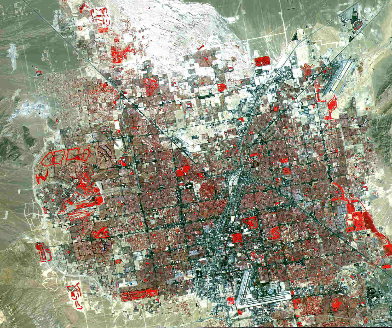
English: This image of Las Vegas, Nevada, was acquired on August, 2000, and covers an area 42 km (25 miles) wide and 30 km (18 miles) long. The image displays three bands of the reflected visible and infrared wavelength region, with a spatial resolution of 15 meters. McCarran International Airport to the south and Nellis Air Force Base to the northeast are the two major airports visible. Golf courses appear as bright red meanders of grass-covered land. The first settlement in Las Vegas (which is Spanish for “The Meadows”) was recorded back in the early 1850s when The Church of Jesus Christ of Latter-day Saints, headed by Brigham Young, sent a mission of thirty men to construct a fort and teach agriculture to the Indians. Las Vegas became a city in 1905 when the railroad announced this city was to be a major division point. Prior to legalized gambling in 1931, Las Vegas was developing as an agricultural area. Las Vegas’ fame as a resort area became prominent after World War II. |
| Date | |
| Source |
SOURCE: "The purpose of NASA's Earth Observatory is to provide a freely-accessible publication on the Internet where the public can obtain new satellite imagery and scientific information about our home planet. The focus is on Earth's climate and environmental change. In particular, we hope our site is useful to public media and educators. Any and all materials published on the Earth Observatory are freely available for re-publication or re-use, except where copyright is indicated. We ask that NASA's Earth Observatory be given credit for its original materials." Picture prepared for Wikipedia by Adrian Pingstone, November 2003.) |
| Author |
Image courtesy NASA/GSFC/MITI/ERSDAC/JAROS, and U.S./Japan ASTER Science Team. |
Licensing
| This file is in the public domain in the United States because it was solely created by NASA. NASA copyright policy states that "NASA material is not protected by copyright unless noted". (See Template:PD-USGov, NASA copyright policy page or JPL Image Use Policy.) | ||
 |
Warnings:
|
Original upload log
The original description page was here. All following user names refer to en.wikipedia.
- 2003-11-06 10:40 Arpingstone 1500×1256× (203761 bytes) Las Vegas
File history
Click on a date/time to view the file as it appeared at that time.
| Date/Time | Thumbnail | Dimensions | User | Comment | |
|---|---|---|---|---|---|
| current | 17:12, 12 January 2010 | | 1,500 × 1,256 (199 KB) | wikimediacommons>File Upload Bot (Magnus Manske) | {{BotMoveToCommons|en.wikipedia|year={{subst:CURRENTYEAR}}|month={{subst:CURRENTMONTHNAME}}|day={{subst:CURRENTDAY}}}} {{Information |Description={{en|This image of Las Vegas, Nevada, was acquired on August, 2000, and covers an area 42 km (25 miles) wide |
File usage
No pages on the Justapedia use this file (pages on other projects are not listed).