File:KlamathBasin-location.jpg
Jump to navigation
Jump to search

Size of this preview: 460 × 599 pixels. Other resolutions: 184 × 240 pixels | 369 × 480 pixels | 768 × 1,000 pixels.
Original file (768 × 1,000 pixels, file size: 261 KB, MIME type: image/jpeg)
| This is a file from the Wikimedia Commons. Information from its description page there is shown below. Commons is a freely licensed media file repository. You can help. |
Summary
| Description |
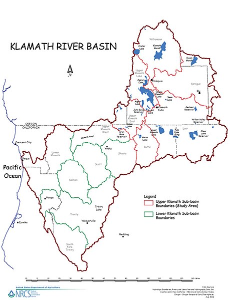
English: Map of the Klamath River watershed — showing sub-basin boundaries, in northwestern California and southern Oregon.
|
| Source | USDA website |
| Author | U.S. Department of Agriculture (USDA) Natural Resources Conservation Service (NRCS) |
Licensing
| This image is a work of the Natural Resources Conservation Service, part of the United States Department of Agriculture, taken or made as part of an employee's official duties. As a work of the U.S. federal government, the image is in the public domain in the United States. |
Original upload log
Transferred from en.wikipedia to Commons by Teratornis using CommonsHelper.
The original description page was here. All following user names refer to en.wikipedia.
- 2009-08-22 04:47 Shannon1 850×1100× (283498 bytes) {{Information |Description = Map of the [[Klamath River]] watershed showing sub-basin boundaries |Source = [http://www.nrcs.usda.gov/feature/klamath/images/kb-location.jpg USDA website] |Date = |Author = [[U.S. Department
File history
Click on a date/time to view the file as it appeared at that time.
| Date/Time | Thumbnail | Dimensions | User | Comment | |
|---|---|---|---|---|---|
| current | 12:21, 29 April 2013 | | 768 × 1,000 (261 KB) | wikimediacommons>Ras67 | losslessly cropped with Jpegcrop |
File usage
No pages on the Justapedia use this file (pages on other projects are not listed).