File:Great Trek map full.png
Jump to navigation
Jump to search
Size of this preview: 700 × 600 pixels. Other resolutions: 280 × 240 pixels | 560 × 480 pixels | 896 × 768 pixels | 1,195 × 1,024 pixels | 2,390 × 2,048 pixels | 4,636 × 3,973 pixels.
Original file (4,636 × 3,973 pixels, file size: 2.53 MB, MIME type: image/png)
| This is a file from the Wikimedia Commons. Information from its description page there is shown below. Commons is a freely licensed media file repository. You can help. |

|
This transport map image could be re-created using vector graphics as an SVG file. This has several advantages; see Commons:Media for cleanup for more information. If an SVG form of this image is available, please upload it and afterwards replace this template with
{{vector version available|new image name}}.
It is recommended to name the SVG file “Great Trek map full.svg”—then the template Vector version available (or Vva) does not need the new image name parameter. |
Summary
| Description |
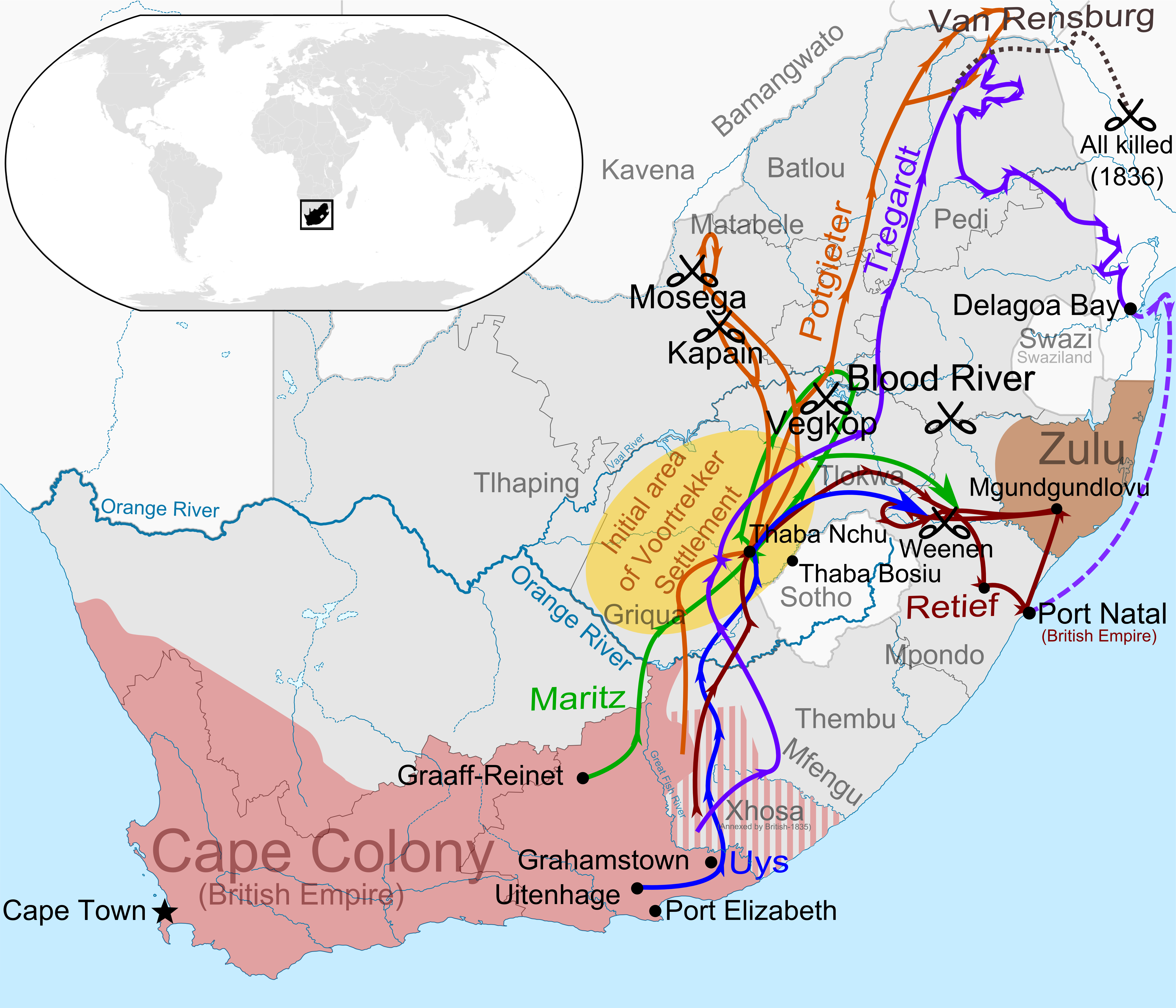
Afrikaans: Kaart van die eerste uittog van die Groot Trek (1835-1840), met die roetes van die grootste trekpartye van die Voortrekkers aangedui. Gebaseer op 'n kaart in "The Great Trek" (1985) deur B.P.J. Erasmus en die "Illustrated History of South Africa: The Real Story" deur Reader's Digest (1988), bladsy 115.
Louis Tregardt se roete (1833 tot 1838)
Oorlewendes van Tregardt se trek per skip ontruim, 1839
Hans van Rensburg se roete, na skeiding van Tregardt s'n, almal uitgemoor in 1836
Hendrik Potgieter se trek-, kampanje- en verkenningsroetes
Gerrit Maritz se roete
Piet Retief se roete, insluitend sendings met sy gevolg
Piet Uys se roete
English: A map of the first wave of the Great Trek (1835-1840) illustrating the paths of the largest parties of Voortrekkers across Southern Africa.
Louis Tregardt's route (1833 to 1838)
Survivors of Tregardt's trek evacuated by sea, 1839
Van Rensburg's route, after it separated from Tregardt's, all killed in 1836
Hendrik Potgieter's trek, campaign and scouting routes
Gerrit Maritz's route
Piet Retief's route, including missions with his entourage
Piet Uys's route |
| Date | |
| Source |
Own work using:
|
| Author | Discott |
Licensing
I, the copyright holder of this work, hereby publish it under the following license:
This file is licensed under the Creative Commons Attribution-Share Alike 4.0 International license.
- You are free:
- to share – to copy, distribute and transmit the work
- to remix – to adapt the work
- Under the following conditions:
- attribution – You must give appropriate credit, provide a link to the license, and indicate if changes were made. You may do so in any reasonable manner, but not in any way that suggests the licensor endorses you or your use.
- share alike – If you remix, transform, or build upon the material, you must distribute your contributions under the same or compatible license as the original.
File history
Click on a date/time to view the file as it appeared at that time.
| Date/Time | Thumbnail | Dimensions | User | Comment | |
|---|---|---|---|---|---|
| current | 15:52, 17 March 2016 | | 4,636 × 3,973 (2.53 MB) | wikimediacommons>Discott | corrected 1838 to 1836 |
File usage
The following pages use this file on Justapedia (pages on other projects are not listed):