File:FCAB EMD GR12 and two Clyde GL26C-2 crossing Salar de Ascotan, Chile.jpg
Jump to navigation
Jump to search
Size of this preview: 800 × 494 pixels. Other resolutions: 320 × 198 pixels | 640 × 395 pixels | 1,024 × 632 pixels | 1,280 × 790 pixels | 2,560 × 1,580 pixels | 4,752 × 2,933 pixels.
Original file (4,752 × 2,933 pixels, file size: 4.04 MB, MIME type: image/jpeg)
| This is a file from the Wikimedia Commons. Information from its description page there is shown below. Commons is a freely licensed media file repository. You can help. |
Summary
| Description |
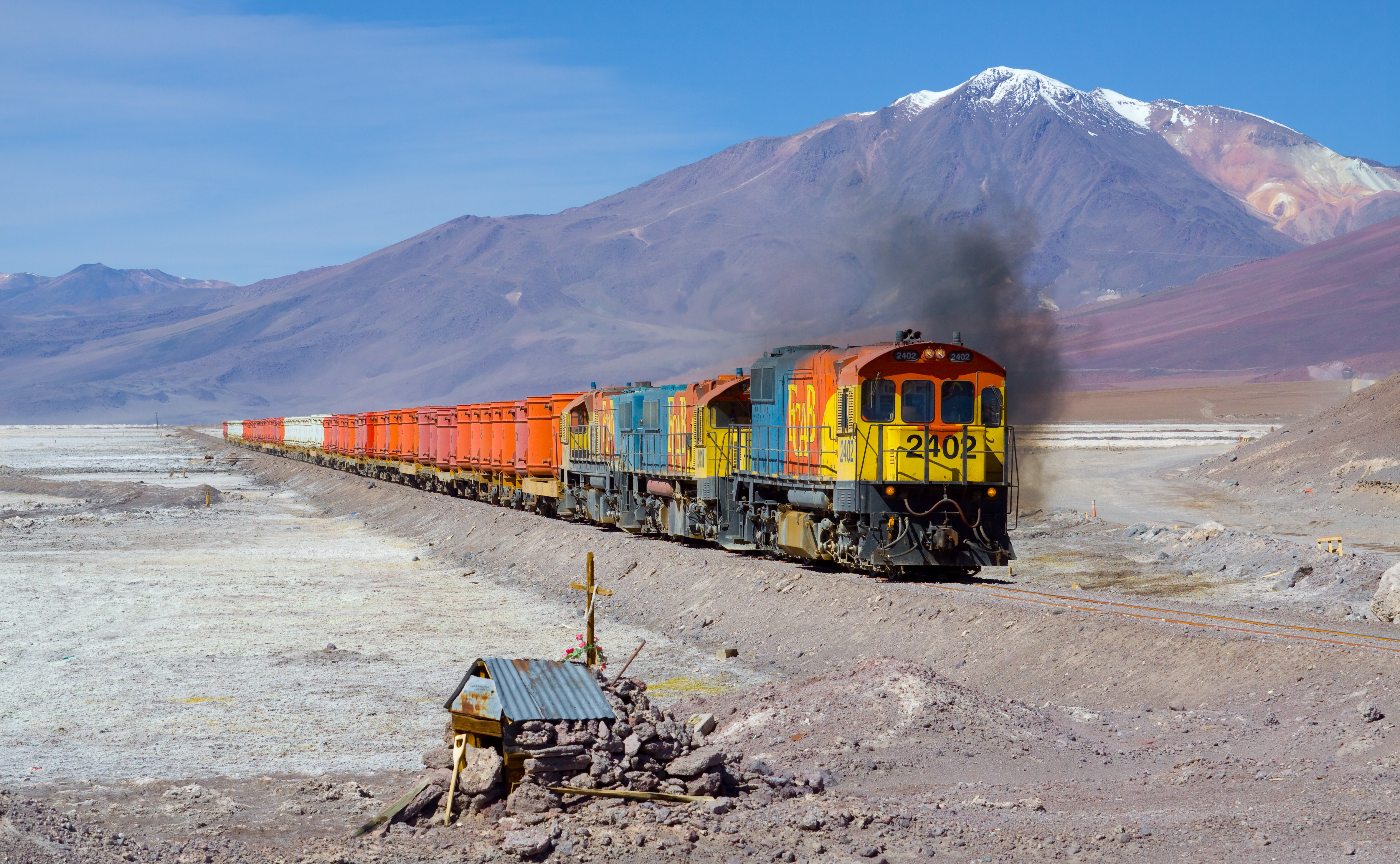
English: Three FCAB engines with a "bucket train" crossing the Salar de Ascotan (salt lake Ascotan) on their journey from Calama to Ollagüe (at the Bolivian border), Chile. The buckets are probably empty; they are used to transport ore from Bolivia to the ports of Chile. The engines are EMD GR12 2402, EMD/Clyde GL26C-2 2010 and EMD/Clyde GL26C-2 2005. In the background you can see the 5846 m high stratovolcano "Cerro del Azufre".
Deutsch: Drei FCAB-Loks queren mit ihrem Kübel-Zug den Salar de Ascotan (Salzsee Ascotan) auf ihrer Fahrt von Calama nach Ollagüe (an der Grenze zu Bolivien), Chile. Die Kübel sind vermutlich leer; sie werden für den Transport von verschiedenen Erzen von Bolivien zu den Häfen Chiles benötigt. Die Loks sind EMD GR12 2402, EMD/Clyde GL26C-2 2010 und EMD/Clyde GL26C-2 2005. Im Hintergrund ist der 5846 m hohe Stratovulkan "Cerro del Azufre" sichtbar. |
| Date | |
| Source | Own work: http://www.bahnbilder.ch/picture/10318 |
| Author | Kabelleger / David Gubler (http://www.bahnbilder.ch) |
| Camera location | | View this and other nearby images on: OpenStreetMap |
|---|
Assessment
|
Licensing
I, the copyright holder of this work, hereby publish it under the following licenses:

|
Permission is granted to copy, distribute and/or modify this document under the terms of the GNU Free Documentation License, Version 1.2 or any later version published by the Free Software Foundation; with no Invariant Sections, no Front-Cover Texts, and no Back-Cover Texts. A copy of the license is included in the section entitled GNU Free Documentation License. |
This file is licensed under the Creative Commons Attribution-Share Alike 3.0 Unported, 2.5 Generic, 2.0 Generic and 1.0 Generic license.
- You are free:
- to share – to copy, distribute and transmit the work
- to remix – to adapt the work
- Under the following conditions:
- attribution – You must give appropriate credit, provide a link to the license, and indicate if changes were made. You may do so in any reasonable manner, but not in any way that suggests the licensor endorses you or your use.
- share alike – If you remix, transform, or build upon the material, you must distribute your contributions under the same or compatible license as the original.
You may select the license of your choice.
| Annotations | This image is annotated: View the annotations at Commons |
File history
Click on a date/time to view the file as it appeared at that time.
| Date/Time | Thumbnail | Dimensions | User | Comment | |
|---|---|---|---|---|---|
| current | 00:36, 4 June 2012 | | 4,752 × 2,933 (4.04 MB) | wikimediacommons>Kabelleger | {{Information |Description ={{en|1=Three FCAB engines with a "bucket train" crossing the Salar de Ascotan (salt lake Ascotan) on their journey from Calama to Ollagüe (at the Bolivian border), Chile. The buckets are probably empty; they are used to ... |
File usage
No pages on the Justapedia use this file (pages on other projects are not listed).