File:ElectoralCollege1868.svg
Jump to navigation
Jump to search

Size of this PNG preview of this SVG file: 800 × 465 pixels. Other resolutions: 320 × 186 pixels | 640 × 372 pixels | 1,024 × 595 pixels | 1,280 × 744 pixels | 2,560 × 1,488 pixels | 1,020 × 593 pixels.
Original file (SVG file, nominally 1,020 × 593 pixels, file size: 78 KB)
| This is a file from the Wikimedia Commons. Information from its description page there is shown below. Commons is a freely licensed media file repository. You can help. |
| U.S. presidential election maps (SVG) |
| See also: National Atlas maps (png) |
|
1789 · 1792 · 1796 · 1800 · 1804 · 1808 · 1812 · 1816 · 1820 · 1824 · 1828 · 1832 · 1836 · 1840 · 1844 · 1848 · 1852 · 1856 · 1860 · 1864 · 1868 · 1872 · 1876 · 1880 · 1884 · 1888 · 1892 · 1896 · 1900 · 1904 · 1908 · 1912 · 1916 · 1920 · 1924 · 1928 · 1932 · 1936 · 1940 · 1944 · 1948 · 1952 · 1956 · 1960 · 1964 · 1968 · 1972 · 1976 · 1980 · 1984 · 1988 · 1992 · 1996 · 2000 · 2004 · 2008 · 2012 · 2016 · 2020 · 2024 |
Summary
| Description |
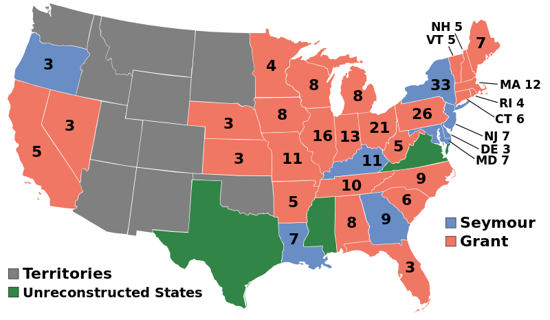
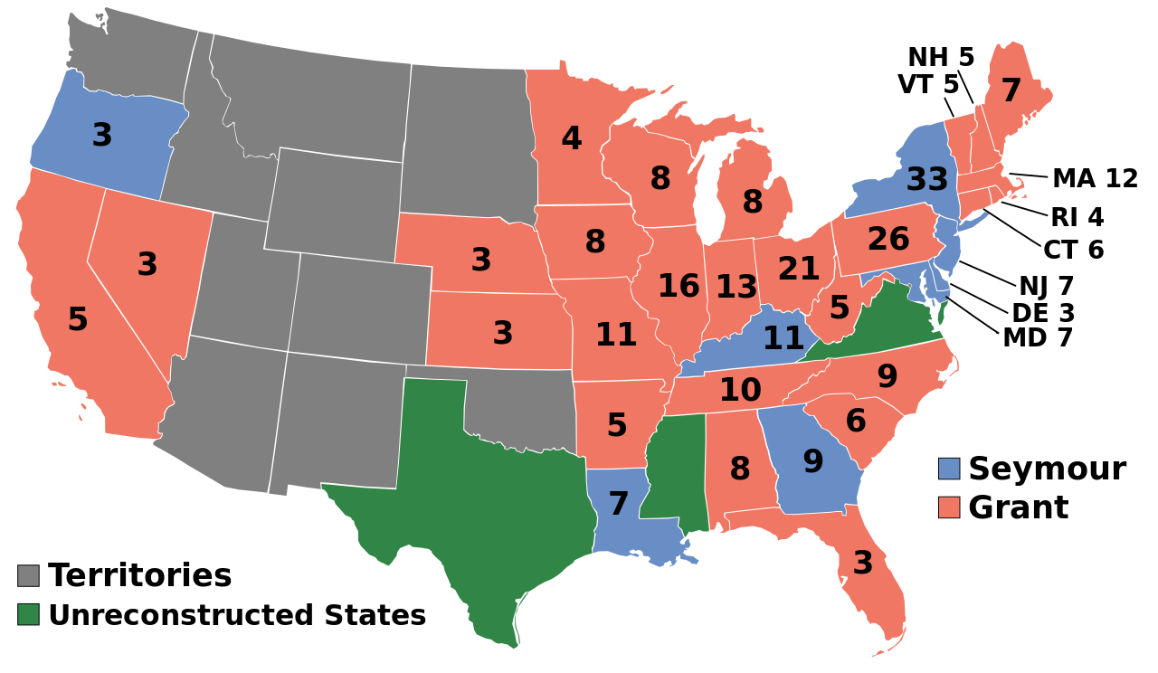
English: 1868 Electoral College |
| Date | Unknown date |
| Source | Own work |
| Author | AndyHogan14 |
Licensing
| I, the copyright holder of this work, release this work into the public domain. This applies worldwide. In some countries this may not be legally possible; if so: I grant anyone the right to use this work for any purpose, without any conditions, unless such conditions are required by law. |
File history
Click on a date/time to view the file as it appeared at that time.
| Date/Time | Thumbnail | Dimensions | User | Comment | |
|---|---|---|---|---|---|
| current | 08:23, 2 January 2017 | | 1,020 × 593 (78 KB) | wikimediacommons>WikiBunny2K1 | If the green states couldn't vote, the map shouldn't display their electoral votes |
File usage
The following pages use this file on Justapedia (pages on other projects are not listed):