File:Duernkrut3.jpg
Jump to navigation
Jump to search

Size of this preview: 560 × 600 pixels. Other resolutions: 224 × 240 pixels | 448 × 480 pixels | 722 × 773 pixels.
Original file (722 × 773 pixels, file size: 193 KB, MIME type: image/jpeg)
| This is a file from the Wikimedia Commons. Information from its description page there is shown below. Commons is a freely licensed media file repository. You can help. |
| Description |
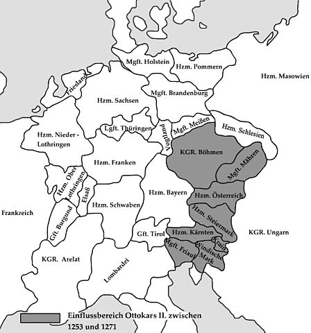
English: Area of Ottokar II of Bohemia. The german abbreviations in the map stand for:
|
| Date | |
| Source | own work by DerBasti |
| Author | DerBasti |
| Permission (Reusing this file) |
released into public domain by DerBasti |
| Other versions | first uploaded to German Wikipedia |
| |
This work has been released into the public domain by its author, DerBasti, at the English Wikipedia project. This applies worldwide. In case this is not legally possible: |

|
This historical map image could be re-created using vector graphics as an SVG file. This has several advantages; see Commons:Media for cleanup for more information. If an SVG form of this image is available, please upload it and afterwards replace this template with
{{vector version available|new image name}}.
It is recommended to name the SVG file “Duernkrut3.svg”—then the template Vector version available (or Vva) does not need the new image name parameter. |


File history
Click on a date/time to view the file as it appeared at that time.
| Date/Time | Thumbnail | Dimensions | User | Comment | |
|---|---|---|---|---|---|
| current | 12:02, 18 July 2016 | | 722 × 773 (193 KB) | wikimediacommons>W like wiki | after advice by de:user:Fit Korr.: "Mgft. Thüringen" > "Lgft. Thüringen" ; "Mgft. Melissen" > "Mgft. Meißen" |
File usage
No pages on the Justapedia use this file (pages on other projects are not listed).