File:Daniel Gumb's cave, near Cheesewring Quarry - geograph.org.uk - 525775.jpg
Jump to navigation
Jump to search
Size of this preview: 400 × 600 pixels. Other resolutions: 160 × 240 pixels | 427 × 640 pixels.
Original file (427 × 640 pixels, file size: 122 KB, MIME type: image/jpeg)
| This is a file from the Wikimedia Commons. Information from its description page there is shown below. Commons is a freely licensed media file repository. You can help. |
Summary
| Description |
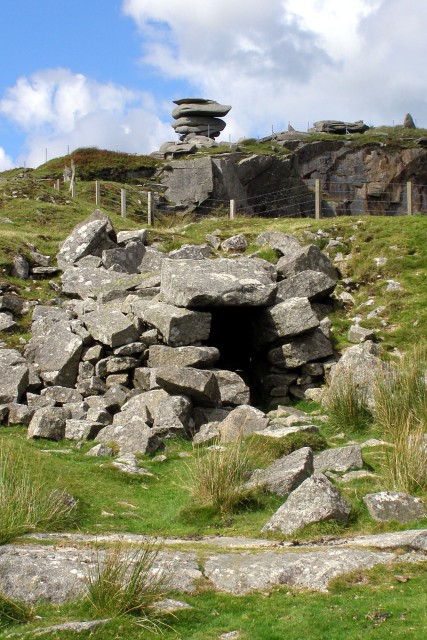
English: Daniel Gumb's cave, near Cheesewring Quarry The dark "cave" in the centre of the photo was home to a stone cutter and mathematician called Daniel Gumb who lived the life of a hermit here until he died in 1776. Some of his geometric diagrams are chiselled into the top of the granite slab that forms the roof of this hermitage. The posts in the background are part of a fence around the Cheesewring Quarry, and up on Stowes Hill is the Cheesewring itself. |
| Date | |
| Source | From geograph.org.uk |
| Author | Jim Champion |
| Attribution (required by the license) | Jim Champion / Daniel Gumb's cave, near Cheesewring Quarry / |
| Camera location | | View this and other nearby images on: OpenStreetMap |
|---|
_heading:0.00&language=en)
| Object location | | View this and other nearby images on: OpenStreetMap |
|---|
_heading:0.00&language=en)
Licensing

|
This image was taken from the Geograph project collection. See this photograph's page on the Geograph website for the photographer's contact details. The copyright on this image is owned by Jim Champion and is licensed for reuse under the Creative Commons Attribution-ShareAlike 2.0 license.
|
This file is licensed under the Creative Commons Attribution-Share Alike 2.0 Generic license.
Attribution: Jim Champion
- You are free:
- to share – to copy, distribute and transmit the work
- to remix – to adapt the work
- Under the following conditions:
- attribution – You must give appropriate credit, provide a link to the license, and indicate if changes were made. You may do so in any reasonable manner, but not in any way that suggests the licensor endorses you or your use.
- share alike – If you remix, transform, or build upon the material, you must distribute your contributions under the same or compatible license as the original.
File history
Click on a date/time to view the file as it appeared at that time.
| Date/Time | Thumbnail | Dimensions | User | Comment | |
|---|---|---|---|---|---|
| current | 19:56, 5 February 2011 | | 427 × 640 (122 KB) | wikimediacommons>GeographBot | == {{int:filedesc}} == {{Information |description={{en|1=Daniel Gumb's cave, near Cheesewring Quarry The dark "cave" in the centre of the photo was home to a stone cutter and mathematician called Daniel Gumb who lived the life of a hermit here until he di |
File usage
No pages on the Justapedia use this file (pages on other projects are not listed).