File:CR HXD1 Yuanlong.jpg
From Justapedia, unleashing the power of collective wisdom
Jump to navigation
Jump to search
![File:CR HXD1 Yuanlong.jpg](https://upload.wikimedia.org/wikipedia/commons/thumb/7/7d/CR_HXD1_Yuanlong.jpg/800px-CR_HXD1_Yuanlong.jpg)
Size of this preview: 800 × 494 pixels. Other resolutions: 320 × 198 pixels | 640 × 395 pixels | 1,024 × 632 pixels | 1,280 × 790 pixels | 2,560 × 1,580 pixels | 5,122 × 3,162 pixels.
Original file (5,122 × 3,162 pixels, file size: 4.05 MB, MIME type: image/jpeg)
![]() | This is a file from the Wikimedia Commons. Information from its description page there is shown below. Commons is a freely licensed media file repository. You can help. |
Summary
DescriptionCR HXD1 Yuanlong.jpg |
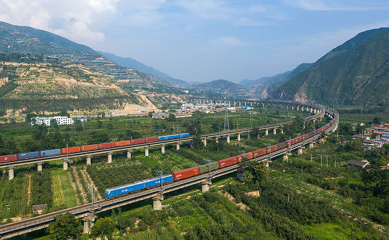
Русский: Участок Баоцзи-Тяньшуй Ланьсиньской железной дороги (Луннань-Урумчи) в районе Майцзи городского округа Тяньшуй в провинции Китая Ганьсу. Оба поезда ведомы электровозами HXD1.
English: Two China Railways freight trains meet on the Longhai line near Yuanlong, between Tianshui and Baoji, China. Both trains are hauled by HXD1 locomotives.
Deutsch: Zwei Güterzüge der China Railways treffen sich auf der Longhai-Linie bei Yuanlong, zwischen Tianshui und Baoji, China. Beide Züge werden von Lokomotiven des Typs HXD1 gezogen.
Français : Deux trains de fret chinois tractés par des locomotives HXD1 se croisant sur des viaducs dans la vallée du Wei He, entre Tianshui et Baoji.
中文:陇海铁路线上和谐号HXD1型电力机车牵引货运列车,位于天水和宝鸡之间 |
Date | |
Source | Own work, also available at https://bahnbilder.ch/picture/19447 |
Author | Kabelleger / David Gubler |
|
Camera location | 34° 32′ 02.31″ N, 106° 13′ 19.96″ E ![]() ![]() | View this and other nearby images on: OpenStreetMap | ![]() |
---|
Licensing
I, the copyright holder of this work, hereby publish it under the following license:
![w:en:Creative Commons](https://upload.wikimedia.org/wikipedia/commons/thumb/7/79/CC_some_rights_reserved.svg/90px-CC_some_rights_reserved.svg.png)
![attribution](https://upload.wikimedia.org/wikipedia/commons/thumb/1/11/Cc-by_new_white.svg/24px-Cc-by_new_white.svg.png)
![share alike](https://upload.wikimedia.org/wikipedia/commons/thumb/d/df/Cc-sa_white.svg/24px-Cc-sa_white.svg.png)
This file is licensed under the Creative Commons Attribution-Share Alike 4.0 International license.
- You are free:
- to share – to copy, distribute and transmit the work
- to remix – to adapt the work
- Under the following conditions:
- attribution – You must give appropriate credit, provide a link to the license, and indicate if changes were made. You may do so in any reasonable manner, but not in any way that suggests the licensor endorses you or your use.
- share alike – If you remix, transform, or build upon the material, you must distribute your contributions under the same or compatible license as the original.
Captions
Add a one-line explanation of what this file represents
some value
27 August 2015
34°32'2.310"N, 106°13'19.956"E
image/jpeg
404e269903a611408cb9336a85a0aabd5f24d342
4,243,017 byte
3,162 pixel
5,122 pixel
File history
Click on a date/time to view the file as it appeared at that time.
Date/Time | Thumbnail | Dimensions | User | Comment | |
---|---|---|---|---|---|
current | 22:58, 30 November 2015 | ![]() | 5,122 × 3,162 (4.05 MB) | wikimediacommons>Kabelleger | User created page with UploadWizard |
File usage
No pages on the Justapedia use this file (pages on other projects are not listed).
Metadata
This file contains additional information, probably added from the digital camera or scanner used to create or digitize it.
If the file has been modified from its original state, some details may not fully reflect the modified file.
Camera manufacturer | Canon |
---|---|
Camera model | Canon EOS 5D Mark III |
Author | David Gubler bahnbilder.ch |
Exposure time | 1/1,000 sec (0.001) |
F-number | f/7.1 |
ISO speed rating | 250 |
Date and time of data generation | 16:47, 27 August 2015 |
Lens focal length | 28 mm |
Latitude | 34° 32′ 2.31″ N |
Longitude | 106° 13′ 19.96″ E |
Altitude | 1,050.2 meters above sea level |
Orientation | Normal |
Horizontal resolution | 240 dpi |
Vertical resolution | 240 dpi |
File change date and time | 09:22, 6 September 2015 |
Exposure Program | Aperture priority |
Exif version | 2.3 |
Date and time of digitizing | 16:47, 27 August 2015 |
Shutter speed | 9.965784 |
APEX aperture | 5.655638 |
Exposure bias | −0.33333333333333 |
Maximum land aperture | 3 APEX (f/2.83) |
Metering mode | Pattern |
Flash | Flash did not fire |
DateTime subseconds | 91 |
DateTimeOriginal subseconds | 91 |
DateTimeDigitized subseconds | 91 |
Color space | Uncalibrated |
Focal plane X resolution | 160 |
Focal plane Y resolution | 160 |
Focal plane resolution unit | 4 |
Custom image processing | Normal process |
Exposure mode | Auto exposure |
White balance | Auto white balance |
Scene capture type | Standard |
GPS time (atomic clock) | 08:47:38.894 |
Satellites used for measurement | 9 |
Receiver status | Measurement in progress |
Measurement mode | 3-dimensional measurement |
Measurement precision | Good (3.9) |
Speed of GPS receiver | 0 |
Direction of movement | 0 |
Reference for direction of image | Magnetic direction |
Direction of image | 93 |
Geodetic survey data used | WGS-84 |
Bearing of destination | 0 |
Distance to destination | 0 |
GPS date | 27 August 2015 |
GPS differential correction | 0 |
GPS tag version | 0.0.3.2 |
Retrieved from "https://justapedia.org/wiki/File:CR_HXD1_Yuanlong.jpg"