File:Atlas of the Dominion. Counties of Kent and Essex. Province of Ontario. CTASC.jpg
Atlas_of_the_Dominion._Counties_of_Kent_and_Essex._Province_of_Ontario._CTASC.jpg (600 × 462 pixels, file size: 313 KB, MIME type: image/jpeg)
| This is a file from the Wikimedia Commons. Information from its description page there is shown below. Commons is a freely licensed media file repository. You can help. |
Summary
| Title |
Atlas of the Dominion. Counties of Kent and Essex. Province of Ontario. |
||||||||||||||||||||||
| Description |
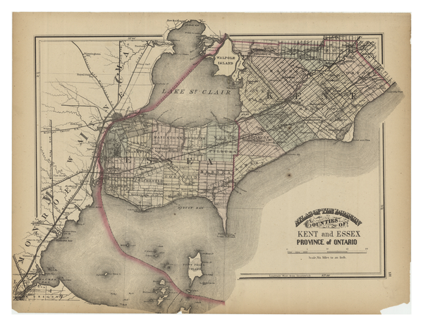
Map of Kent and Essex Counties in Ontario, showing plots of land, some of them numbered. Cities, neighbourhoods, counties, islands, railways, rail stations, and bodies of water are labelled. |
||||||||||||||||||||||
| Subject | Atlases
Atlases--Canada Bodies of water Cities & towns Railroads Railroad stations Counties Windsor (Ont.) Essex (Ont.) Ontario Ontario--Windsor Ontario--Essex Lake Erie |
||||||||||||||||||||||
| Date | |||||||||||||||||||||||
| Source | York University Libraries, Clara Thomas Archives & Special Collections, Historical map collection, HMC0015. http://digital.library.yorku.ca/islandora/object/yul:1153580 | ||||||||||||||||||||||
| Creator |
Walling, Henry Francis, 1825-1888 |
||||||||||||||||||||||
| Credit line | Material digitized as part of an Academic Innovation Fund (AIF), awarded in 2018. For more information see: http://avptl.info.yorku.ca/academic-innovation-fund/ . | ||||||||||||||||||||||
| Geotemporal data | |||||||||||||||||||||||
| Date depicted | |||||||||||||||||||||||
| Map location | Ontario | ||||||||||||||||||||||
| Map type | cartographic | ||||||||||||||||||||||
| Bounding box |
|
||||||||||||||||||||||
| Georeferencing | If inappropriate please set warp_status = skip to hide. | ||||||||||||||||||||||
| Bibliographic data | |||||||||||||||||||||||
| Language | English | ||||||||||||||||||||||
| Publisher |
G.N. Tackabury |
||||||||||||||||||||||
| Archival data | |||||||||||||||||||||||
| Collection |
|
||||||||||||||||||||||
| Accession number |
HMC0015 |
||||||||||||||||||||||
| Dimensions | 1 map : colour ; 32 x 43 cm, on sheet 33 x 44 cm. | ||||||||||||||||||||||
| Notes | Page 131 in Atlas of the Dominion. Scale in the lower right lists the scale as six miles to an inch. | ||||||||||||||||||||||

Licensing
|
This work is in the public domain in its country of origin and other countries and areas where the copyright term is the author's life plus 100 years or fewer. | |
| This file has been identified as being free of known restrictions under copyright law, including all related and neighboring rights. | |
This Canadian work is in the public domain in Canada because its copyright has expired due to one of the following:
it was not subject to Crown copyright, and
|
 |
File history
Click on a date/time to view the file as it appeared at that time.
| Date/Time | Thumbnail | Dimensions | User | Comment | |
|---|---|---|---|---|---|
| current | 17:51, 24 November 2020 | | 600 × 462 (313 KB) | wikimediacommons>Kcohenp | pattypan 20.04 |