File:Angkor Satellit mit Karte.jpg
Jump to navigation
Jump to search
Size of this preview: 800 × 476 pixels. Other resolutions: 320 × 190 pixels | 640 × 381 pixels | 1,024 × 609 pixels.
Original file (1,024 × 609 pixels, file size: 148 KB, MIME type: image/jpeg)
| This is a file from the Wikimedia Commons. Information from its description page there is shown below. Commons is a freely licensed media file repository. You can help. |
|
| Description |
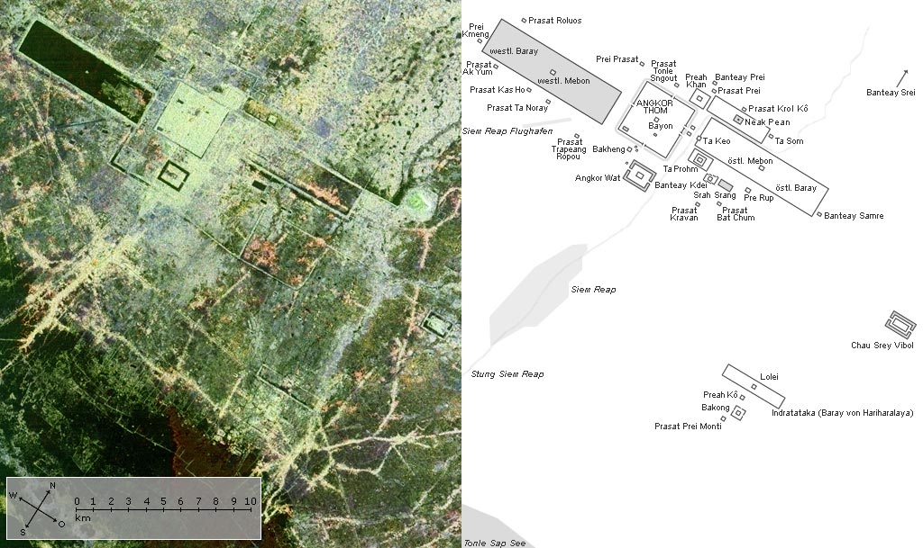
Angkor (Cambodia/Southeast Asia) Deutsch: Die Region von Angkor in Kambodscha. Satellitenaufnahme der NASA, ergänzt um eine Übersichtskarte mit einigen der bedeutendsten Tempelanlagen und Strukturen in Angkor sowie der Stadt Siem Reap, der Landebahn des Flughafens, dem gleichnamigen Fluß und einem Stück des Tonle Sap Sees.
Begriffserklärung zu einigen Namensbestandteilen in Khmer:
English: Satellite image by NASA with a map showing the larger and more important temples and structures of the Angkor area (Cambodia), the city Siem Reap, the airport, the river and a corner of Tonlé Sap lake.
Français : Angkor - plan d'ensemble |
|||||
| Date | ||||||
| Source | NASA, PIA00505 (Spaceborne Imaging Radar-C/X-band Synthetic Aperture Radar, SIR-C/X-SAR) | |||||
| Author | NASA / image editing (color, cropping) and map: Manfred Werner (Tsui) | |||||
| Permission (Reusing this file) |
|
|||||
| Other versions |
 |

| Camera location | | View this and other nearby images on: OpenStreetMap |
|---|
Original upload log
de.wikipedia
21:32, 17. Jul 2004 . . Tsui (151437 Byte)
21:36, 15. Jul 2004 . . Tsui (106106 Byte) (angkor)
01:27, 6. Jul 2004 . . Tsui (103366 Byte) (angkor)
File history
Click on a date/time to view the file as it appeared at that time.
| Date/Time | Thumbnail | Dimensions | User | Comment | |
|---|---|---|---|---|---|
| current | 11:23, 17 September 2005 | | 1,024 × 609 (148 KB) | wikimediacommons>Saperaud~commonswiki | '''Angkor''' (Kambodscha/Südostasien) '''Satellitenaufnahme''' der NASA, ergänzt um eine '''Übersichtskarte mit einigen der bedeutendsten Tempelanlagen''' und Strukturen in Angkor sowie der Stadt Siem Reap, der Landebahn des Flughafens |
File usage
No pages on the Justapedia use this file (pages on other projects are not listed).