File:AmesRangeMap.jpg
Jump to navigation
Jump to search

Size of this preview: 750 × 600 pixels. Other resolutions: 300 × 240 pixels | 600 × 480 pixels | 1,000 × 800 pixels.
Original file (1,000 × 800 pixels, file size: 165 KB, MIME type: image/jpeg)
| This is a file from the Wikimedia Commons. Information from its description page there is shown below. Commons is a freely licensed media file repository. You can help. |
Summary
| Description |
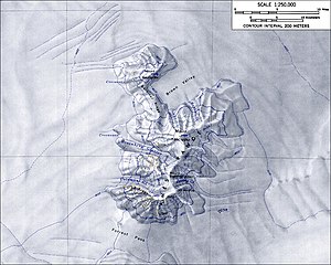
English: Topographical map of the Ames Range
From http://usarc.usgs.gov/antarctic_atlas/ |
| Source | Transferred from en.wikipedia to Commons. See also 1:250 000 map of Mount Kosciusko from the USGS. |
| Author |
Licensing
This image is in the public domain in the United States because it only contains materials that originally came from the United States Geological Survey, an agency of the United States Department of the Interior. For more information, see the official USGS copyright policy.
|
Original upload log
The original description page was here. All following user names refer to en.wikipedia.
- 2005-01-04 15:51 GarciaB 1000×800×8 (169185 bytes) Topographic map of the Ames Range (1:250,000 scale)
File history
Click on a date/time to view the file as it appeared at that time.
| Date/Time | Thumbnail | Dimensions | User | Comment | |
|---|---|---|---|---|---|
| current | 00:01, 6 February 2008 | | 1,000 × 800 (165 KB) | wikimediacommons>Alison | {{Information |Description={{en|Topographical map of the Ames Range From http://usarc.usgs.gov/antarctic_atlas/}} |Source=Transferred from [http://en.wikipedia.org en.wikipedia] |Date=2005-01-04 (original upload date) |Author=Original uploader was [[:en: |
File usage
No pages on the Justapedia use this file (pages on other projects are not listed).