File:Administrative map of Erivan Governorate - 1913.gif
Jump to navigation
Jump to search

Size of this preview: 724 × 599 pixels. Other resolutions: 290 × 240 pixels | 580 × 480 pixels | 928 × 768 pixels | 1,237 × 1,024 pixels | 1,491 × 1,234 pixels.
Original file (1,491 × 1,234 pixels, file size: 443 KB, MIME type: image/gif)
| This is a file from the Wikimedia Commons. Information from its description page there is shown below. Commons is a freely licensed media file repository. You can help. |
Summary
| Description |
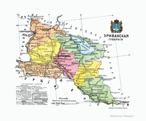
English: Administrative map of Kars Oblast: showing the main settlements. |
| Date | |
| Source |
Русский: II. Азiатская Россiя. XV. Кавказскiй край. — Эриванская губерния, стр. 80 // Россiя. Географическое описанiе Россiйской Имперiи по губернiямъ и областямъ съ географическими картами. Санкт–Петербургь: Типографія "Бережливость", 1913.
|
| Author | Русский: Отпечатано в картографическом заведении Д. М. Руднева в Санкт—Петербурге. |
Licensing
|
This is a faithful photographic reproduction of a two-dimensional, public domain work of art. The work of art itself is in the public domain for the following reason:
The official position taken by the Wikimedia Foundation is that "faithful reproductions of two-dimensional public domain works of art are public domain".
This photographic reproduction is therefore also considered to be in the public domain in the United States. In other jurisdictions, re-use of this content may be restricted; see Reuse of PD-Art photographs for details. | ||||
File history
Click on a date/time to view the file as it appeared at that time.
| Date/Time | Thumbnail | Dimensions | User | Comment | |
|---|---|---|---|---|---|
| current | 00:22, 4 February 2017 | | 1,491 × 1,234 (443 KB) | wikimediacommons>Well-read MountainMan | User created page with UploadWizard |
File usage
No pages on the Justapedia use this file (pages on other projects are not listed).