File:1856 Kiepert Map of Lebanon - Geographicus - Lebanon-kiepert-1856.jpg
Jump to navigation
Jump to search

Size of this preview: 489 × 599 pixels. Other resolutions: 196 × 240 pixels | 392 × 480 pixels | 627 × 768 pixels | 836 × 1,024 pixels | 1,672 × 2,048 pixels | 3,000 × 3,675 pixels.
Original file (3,000 × 3,675 pixels, file size: 2.45 MB, MIME type: image/jpeg)
| This is a file from the Wikimedia Commons. Information from its description page there is shown below. Commons is a freely licensed media file repository. You can help. |
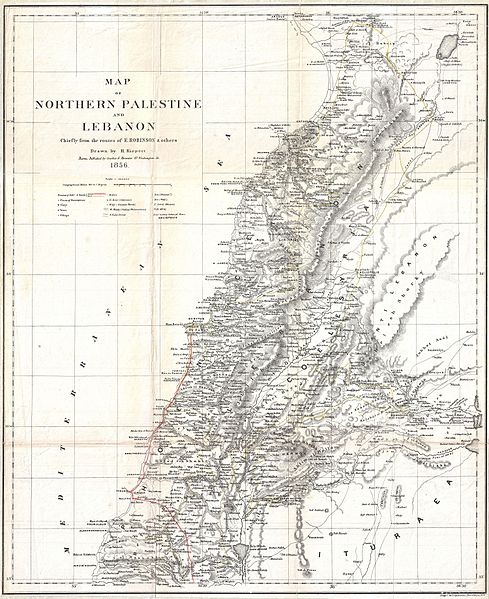
| Heinrich Kiepert: Map of Northern Palestine and Lebanon Chiefly from the Routes of E. Robinson & others.
( |
||||||||||||||||||||||||
|---|---|---|---|---|---|---|---|---|---|---|---|---|---|---|---|---|---|---|---|---|---|---|---|---|
| Artist |
|
|||||||||||||||||||||||
| Title |
Map of Northern Palestine and Lebanon Chiefly from the Routes of E. Robinson & others. |
|||||||||||||||||||||||
| Description |
English: An uncommon map of Lebanon by the classical scholar and cartographer H. Kiepert. Covers all of modern day Lebanon as well as parts of adjacent Israel, Palestine, Jordan and Syria. This map is based on the 1838 travels of E. Robinson and E. Smith in this area. Robinson and Smith, in search of unidentified Biblical sites, traveled throughout the Middle East but most particularly in modern day Israel, Palestine, Lebanon, Egypt, Jordan, and Syria. The duo used local traditions as well as established Biblical scholarship to identify a number of important sites. This map is largely the result of their research and work. Their route, shown in red, leads Israel northwards to Tyre then skirts the coast to Beiruit. Most place names are transliterations of Arabic though biblical references are included where appropriate. This map was drawn by Heinrich Kiepert, a noted expert on historical cartography, for Robinson’s important work Biblical Researches in Palestine, and in the Adjacent Regions. |
|||||||||||||||||||||||
| Date | 1856 (undated) | |||||||||||||||||||||||
| Dimensions | height: 20 in (50.8 cm); width: 16.5 in (41.9 cm) | |||||||||||||||||||||||
| Accession number |
Geographicus link: Lebanon-kiepert-1856 |
|||||||||||||||||||||||
| Source/Photographer |
Robinson, E., and Smith, E., Biblical Researches in Palestine, and in the Adjacent Regions. A Journal of Travels in the Year 1838. (Boston: Crocker & Brewster) 1856.
|
|||||||||||||||||||||||
| Permission (Reusing this file) |
|
|||||||||||||||||||||||
Loescher_%26_btv1b8453164n_(cropped).jpg)
File history
Click on a date/time to view the file as it appeared at that time.
| Date/Time | Thumbnail | Dimensions | User | Comment | |
|---|---|---|---|---|---|
| current | 02:16, 25 March 2011 | | 3,000 × 3,675 (2.45 MB) | wikimediacommons>BotMultichillT | {{subst:User:Multichill/Geographicus |link=http://www.geographicus.com/P/AntiqueMap/Lebanon-kiepert-1856 |product_name=1856 Kiepert Map of Lebanon |map_title=Map of Northern Palestine and Lebanon Chiefly from the Routes of E. Robinson & others. |descripti |
File usage
The following pages use this file on Justapedia (pages on other projects are not listed):
BoilerPlate was here