File:1826 CourtSt map Boston byStephenPFuller detail BPL10344.png
Jump to navigation
Jump to search

Size of this preview: 800 × 598 pixels. Other resolutions: 320 × 239 pixels | 640 × 479 pixels | 805 × 602 pixels.
Original file (805 × 602 pixels, file size: 958 KB, MIME type: image/png)
| This is a file from the Wikimedia Commons. Information from its description page there is shown below. Commons is a freely licensed media file repository. You can help. |
| Description |
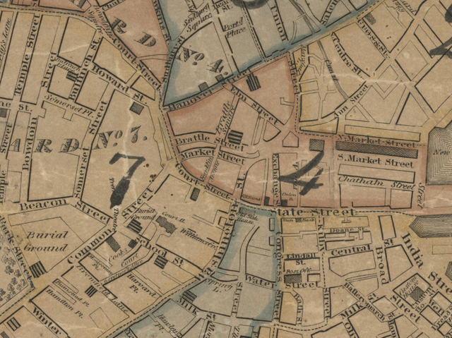
Detail of 1826 map of Boston by Stephen P. Fuller, showing Court Street, Brattle Street, Market Street and vicinity. Title: Plan of Boston comprising a part of Charlestown and Cambridge. Author: Fuller, Stephen P. Publisher: Annin & Smith. Date: 1826. |
| Date | |
| Source | http://maps.bpl.org/details_10344 |
| Author | Fuller |
This media file is in the public domain in the United States. This applies to U.S. works where the copyright has expired, often because its first publication occurred prior to January 1, 1929, and if not then due to lack of notice or renewal. See this page for further explanation.
|
 | |
 |
This image might not be in the public domain outside of the United States; this especially applies in the countries and areas that do not apply the rule of the shorter term for US works, such as Canada, Mainland China (not Hong Kong or Macao), Germany, Mexico, and Switzerland. The creator and year of publication are essential information and must be provided. See Wikipedia:Public domain and Wikipedia:Copyrights for more details.
|
File history
Click on a date/time to view the file as it appeared at that time.
| Date/Time | Thumbnail | Dimensions | User | Comment | |
|---|---|---|---|---|---|
| current | 01:31, 28 January 2010 | | 805 × 602 (958 KB) | wikimediacommons>M2545 | {{Information |Description=Detail of 1826 map of Boston by Stephen P. Fuller, showing Court Street, Brattle Street, Market Street and vicinity. Title: Plan of Boston comprising a part of Charlestown and Cambridge. Author: Fuller, Stephen P. Publis |
File usage
No pages on the Justapedia use this file (pages on other projects are not listed).