File:120408 Pheriche Pano 4k.jpg
Jump to navigation
Jump to search

Size of this preview: 800 × 500 pixels. Other resolutions: 320 × 200 pixels | 640 × 400 pixels | 1,024 × 640 pixels | 1,280 × 800 pixels | 2,560 × 1,600 pixels | 3,840 × 2,400 pixels.
Original file (3,840 × 2,400 pixels, file size: 5.16 MB, MIME type: image/jpeg)
| This is a file from the Wikimedia Commons. Information from its description page there is shown below. Commons is a freely licensed media file repository. You can help. |
Summary
| Description |
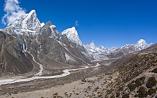
English: Panorama view of the Khumbu Khola valley above Pheriche. To the left are the peaks of Tawoche (6542m) and Cholatse (6440m).
|
| Date | |
| Source | Own work |
| Author | Faj2323 |
| Camera location | | View this and other nearby images on: OpenStreetMap |
|---|
Assessment
|
This image was selected as picture of the day on Wikimedia Commons for 5 April 2023. It was captioned as follows: English: Panorama view of the Khumbu Khola valley above Pheriche. To the left are the peaks of Tawoche (6542 m) and Cholatse (6440 m). Other languages:
Čeština: Panoramatický pohled na údolí Khumbu Khola valley nad vesnicí Pheriche v Nepálu. Horské vrcholy (zleva) Taboče (6 542 m) a Čolace (6 440 m). Deutsch: Panoramablick auf das Khumbu Khola-Tal oberhalb von Pheriche (Nepal). Links sind die Gipfel Taboche (6542 m) und Cholatse (6440 m) zu sehen. English: Panorama view of the Khumbu Khola valley above Pheriche. To the left are the peaks of Tawoche (6542 m) and Cholatse (6440 m). Español: Vista panorámica del valle de Khumbu Khola al noroeste de Pheriche. A la izquierda están los picos de Taboche (6542 m) y Cholatse (6440 m). Français : Les monts Tawesche (gauche) et Cholatse (droite), hautes montagnes de l'Himalaya situées au Népal. Le Tawesche est considéré comme une montagne sacrée. Italiano: Vista panoramica della valle di Khumbu Khola, sopra il villaggio di Pheriche. A sinistra si vedono le cime del Taboche (6 542 m) e del Cholatse (6 440 m). Magyar: A Khumbu Khola-völgy panorámaképe Pheriche felett. Balra a Tawoche (6542 m) és a Cholatse (6440 m) csúcsai (Himalája, Nepál) Nederlands: Hooggebergte in de Khumbu in Nepal, waar naast de op de foto zichtbare Taboche (6542 m) en Cholatse (6440 m) ook de mount Everest (8849 m), de hoogste berg ter wereld, te vinden is. Português: Vista panorâmica do vale de Khumbu Khola ao noroeste da vila Pheriche, nordeste do Nepal. À esquerda estão os picos Taboche (6 542 m) e Cholatse (6 440 m). Slovenščina: Panoramski pogled na dolino Kumbu Kola nad vasjo Periče. Levo sta vrhova Tavoče (6542 m) in Čolatse (6440 m). Македонски: Поглед на долината Кумбу Кола во Непал. |
This image was uploaded as part of Wiki Loves Earth 2017.
|
 |

|
This image won the 1st prize in the national contest of Nepal in Wiki Loves Earth 2017 Other languages:
|
This image has been assessed using the Quality image guidelines and is considered a Quality image.
|
Licensing
I, the copyright holder of this work, hereby publish it under the following license:
This file is licensed under the Creative Commons Attribution-Share Alike 4.0 International license.
- You are free:
- to share – to copy, distribute and transmit the work
- to remix – to adapt the work
- Under the following conditions:
- attribution – You must give appropriate credit, provide a link to the license, and indicate if changes were made. You may do so in any reasonable manner, but not in any way that suggests the licensor endorses you or your use.
- share alike – If you remix, transform, or build upon the material, you must distribute your contributions under the same or compatible license as the original.
| Annotations | This image is annotated: View the annotations at Commons |
File history
Click on a date/time to view the file as it appeared at that time.
| Date/Time | Thumbnail | Dimensions | User | Comment | |
|---|---|---|---|---|---|
| current | 14:39, 28 May 2017 | | 3,840 × 2,400 (5.16 MB) | wikimediacommons>Faj2323 | User created page with UploadWizard |
File usage
No pages on the Justapedia use this file (pages on other projects are not listed).