1994–95 South Pacific cyclone season
| 1994–95 South Pacific cyclone season | |
|---|---|
 Season summary map | |
| Seasonal boundaries | |
| First system formed | November 12, 1994 |
| Last system dissipated | March 17, 1995 |
| Strongest storm | |
| Name | William |
| • Maximum winds | 110 km/h (70 mph) (10-minute sustained) |
| • Lowest pressure | 975 hPa (mbar) |
| Seasonal statistics | |
| Total depressions | 4 |
| Tropical cyclones | 2 (record low) |
| Severe tropical cyclones | 0 (record low, tied with 2008–09) |
| Total fatalities | None reported |
| Total damage | $2.5 million (1995 USD) |
| Related articles | |
The 1994–95 South Pacific cyclone season was the least active South Pacific tropical cyclone season on record, with only two tropical cyclones officially occurring within the South Pacific Ocean basin between 160°E and 120°W. The season ran from November 1, 1994, until April 30, 1995, with the first disturbance of the season developing on November 12 and the last disturbance dissipating on March 17. The most intense tropical cyclone during the season was Tropical Cyclone William, which affected the Cook Islands. After the season the name William was retired from the tropical cyclone naming lists.
During the season, tropical cyclones were officially monitored by the Fiji Meteorological Service, New Zealand's MetService and Australia's Bureau of Meteorology.[1] Throughout the season the United States Navy also monitored the basin and issued unofficial warnings, through its Joint Typhoon Warning Center (JTWC) and Naval Pacific Meteorology and Oceanography Center (NPMOC).[2] Tropical cyclones that were located between the Equator and 25S were monitored by the FMS while any that were located to the south of 25S were monitored by MetService.[1] During the season the JTWC issued warnings on any tropical cyclone that was located between 160°E and 180° while the NPMOC issued warnings for tropical cyclones forming between 180° and the American coast.[2] The FMS, MetService and BoM all used the Australian Tropical Cyclone Intensity Scale, and measured windspeeds over a 10-minute period, while the JTWC and the NPMOC measured sustained windspeeds over a 1-minute period.[1]
Seasonal summary
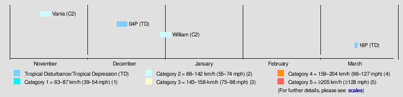
The season was one of the most inactive tropical cyclone seasons on record, with only two tropical cyclones officially occurring within the South Pacific Ocean basin between 160°E and 120°W.[3] The first tropical depression of the season developed out of an area of convection on November 12 to the northeast of Vanuatu, before it was named Vania on November 14 after it had become a category 1 tropical cyclone.[3] The cyclone went on to end a long dry spell in Vanuatu, before it last noted on November 19 to the west of Port Vila, Vanuatu. The basin remained quiet until December 13, when Tropical Depression 04P developed to the east of the Solomon Islands, before going on to affect Fiji and Tonga.[4] During the final days of 1994, several areas of low pressure developed, within the South Pacific Convergence Zone between 8°S and 16°S, and 180°W and 160°W. During December 30, one of these areas of low pressure developed into a tropical depression, within the northern Cook Islands just to the east of Pukapuka atoll.[5] Over the next couple of days, the depression moved southeastwards towards the Southern Cook Islands and gradually developed into Tropical Cyclone William.[6] Throughout its lifetime, William moved southeast and affected parts of French Polynesia and the Cook Islands before becoming extratropical on January 3.[7] After William left the basin on January 5, the basin remained quiet until March 16, when Tropical Depression 18P developed near Fiji, before dissipating during the next day.[8]
After the season had ended, the name William was retired from the tropical cyclone naming lists, while in June 1995, the World Meteorological Organization designated the FMS as a Regional Specialized Meteorological Center.[9]
Systems
Tropical Cyclone Vania
| Category 2 tropical cyclone (Australian scale) | |
| Tropical storm (SSHWS) | |
  | |
| Duration | November 10 – November 19 |
|---|---|
| Peak intensity | 100 km/h (65 mph) (10-min) 980 hPa (mbar) |
On November 12, TCWC Nadi reported that a tropical depression had developed within a persistent area of convection, that was located about 795 kilometres (495 mi) to the northeast of Port Vila, Vanuatu.[10][6] Over the next couple of days the depression gradually developed further as it started to move towards the southwest, before the JTWC started to issue warnings on it during November 13 and designated it as Tropical Cyclone 01P after it had become equivalent to a tropical storm.[2][10] Early on November 14, as the system passed near the Solomon Island of Tikopia, TCWC Nadi reported that the system had become a category 1 tropical cyclone on the Australian scale, and named it as Vania. During that day as it continued to move towards the south — southwest and intensify, it started to affect Vanuatu with storm force windspeeds and heavy rain which helped break a long dry spell in Vanuatu.[6]
Early on November 15, TCWC Nadi reported that Vania had become a category two tropical cyclone with peak 10-minute sustained windspeeds of between 100 km/h (60 mph), while the JTWC reported peak 1-minute sustained windspeeds of 110 km/h (70 mph) which made it equivalent to a tropical storm.[10] Later that day Vania passed near or over several of the Vanuatuan islands as it continued to move towards the south — southwest, and started to weaken as it encountered a higher amount of vertical windshear. During the following day, TCWC Nadi reported that Vania had weakened into a category one tropical cyclone as the systems low level circulation stalled, before it turned and started to move westwards while located to the north of New Caledonia.[6][10] During November 17, as the system had become sheared the JTWC issued their final advisory on Vania, before the systems remnant low level circulation was last noted by TCWC Nadi and the JTWC during November 19, while it was located about 100 km (60 mi) to the west of Port Vila, Vanuatu. Only minor damage to crops and bush houses was reported to have occurred in the archipelago while no deaths were reported.[6] As a result of Vania affecting parts of Vanuatu during November 15, voting in provincial elections had to be extended by 24 hours.[11][12]
Tropical Cyclone 04P
| Tropical depression (FMS) | |
| Tropical storm (SSHWS) | |
  | |
| Duration | December 13 – December 17 |
|---|---|
| Peak intensity | 65 km/h (40 mph) (1-min) 997 hPa (mbar) |
During December 13, a tropical depression developed about 1055 km (655 mi) to the northeast of Suva, Fiji.[13] The system subsequently moved south-eastwards towards Fiji and gradually developed further, before the NPMOC designated the system as Tropical Cyclone 04P and initiated advisories on the depression during December 15.[13][2] At this time, the system was located about 110 km (70 mi) to the northeast of Labasa, Fiji and was estimated to have maximum 1-minute sustained wind-speeds of 65 km/h (40 mph).[4] Over the next couple of days, the system passed through Fiji's Lau Islands and Tonga's Haʻapai Group of islands, before system was declared extratropical as it moved below 25S and into MetService's area of responsibility.[4][13] Within Fiji, there were no report of any casualties, damage or gale-force winds associated with the system, however, several pressures of between 995–1000 hectopascals (29.38–29.53 inHg) were reported.[13]
Tropical Cyclone William
| Category 2 tropical cyclone (FMS) | |
| Category 1 tropical cyclone (SSHWS) | |
  | |
| Duration | December 30 – January 3 |
|---|---|
| Peak intensity | 110 km/h (70 mph) (10-min) 975 hPa (mbar) |
On December 30, The FMS reported that a tropical depression had developed about 860 km (535 mi), to the northeast of Pago Pago in American Samoa.[14] Over the next couple of days the system moved towards the south-southeast and gradually developed further, before the NPMOC designated the depression as Tropical Cyclone 05P.[2][7] During January 1, TCWC Nadi reported that the depression had developed into a category 1 tropical cyclone and named it William as it passed near the Cook Island of Autitaki.[7] During the next day William subsequently slowly accelerated as it passed near too or over several other Cook Islands and intensified into a category 2 tropical cyclone.[7]
During January 3, the system passed near or over the French Polynesian islands of Maria and Rimatara, where sustained winds of 115 km/h (71 mph) and wind gusts of up to 154 km/h (96 mph) were recorded.[15] Later that day, both the NPMOC and the FMS estimated that the system had peaked just below hurricane-force with winds of 110 km/h (70 mph), as it left the tropics and transitioned into an extratropical cyclone.[14][7] William's extratropical remnants were tracked by MetService for another couple of days as they moved south-eastwards in the westerlies, before they were last noted near 40.0S 119.5E during January 5, as they moved out of the South Pacific basin.[14] Throughout the Southern Cook Islands caused around US$2.5 million worth of damage to crops, buildings and coconut trees and destroyed a causeway to a tourist resort on Aitutaki.[6][5] William injured two people and destroyed over 150 houses in French Polynesia, where local leaders accused Météo-France off underestimating Williams intensity.[16]
Tropical Depression 18P
| Tropical depression (SSHWS) | |
  | |
| Duration | March 16 – March 17 |
|---|---|
| Peak intensity | 55 km/h (35 mph) (1-min) 1000 hPa (mbar) |
The system that would become Tropical Cyclone 18P was first noted during March 15, while it was located about 250 km (155 mi) to the northeast of Nadi, Fiji.[8] Over the next couple of days, the system moved south-eastwards away from Fiji and was classified as Tropical Cyclone 18P by the NPMOC during March 16, while it was located about 365 km (225 mi) to the south-east of Nuku'alofa in Tonga.[2][17] At this time, the system was estimated by the NPMOC, to have maximum 1-minute sustained wind-speeds of 55 km/h (35 mph).[8] The system subsequently dissipated during the following day, while it was located within MetService's area of responsibility well to the northeast of Wellington, New Zealand.[17] While 18P existed over the South Pacific, a trough of low pressure impacted Fiji, which caused moderate to heavy rain and flooding to be reported in Labasa and Nadi, while over 250 tonnes of canne were destroyed.[18]
Season effects
This table lists all the storms that developed in the South Pacific basin during the 1994–95 season. It includes their intensity on the Australian Tropical cyclone intensity scale, duration, name, areas affected, deaths, and damages. For most storms the data is taken from TCWC Nadi and Wellington's archives, however data for 04P and 18P have been taken from the JTWC archives as opposed to TCWC Nadi and Wellington's, and thus the winds are over 1-minute as opposed to 10-minutes.
| Name | Dates active | Peak intensity | Areas affected | Damage (US$) |
Deaths | Refs | ||
|---|---|---|---|---|---|---|---|---|
| Category | Wind speed | Pressure | ||||||
| Vania | November 12 – 18 | Category 2 tropical cyclone | 100 km/h (65 mph) | 980 hPa (28.94 inHg) | Vanuatu | Unknown | Unknown | [6] |
| 04P | December 15 – 21 | Tropical depression | Not Specified | Not Specified | Fiji, Tonga | Unknown | Unknown | [13] |
| William | December 30, 1994 – January 3, 1995 | Category 2 tropical cyclone | 110 km/h (70 mph) | 975 hPa (28.79 inHg) | Cook Islands, French Polynesia | $2.5 million | None | [6] |
| 18P | March 16 – 17 | Tropical depression | Not Specified | Not Specified | Fiji | Unknown | Unknown | [17] |
| Season aggregates | ||||||||
| 4 systems | November 12, 1994 – March 17, 1995 | 110 km/h (70 mph) | 975 hPa (28.79 inHg) | $2.5 million | ||||
See also
- Atlantic hurricane seasons: 1994, 1995
- Pacific hurricane seasons: 1994, 1995
- Pacific typhoon seasons: 1994, 1995
- North Indian Ocean cyclone seasons: 1994, 1995
References
- ^ a b c RA V Tropical Cyclone Committee (1999). "Tropical Cyclone Operational Plan for the South Pacific and South-East Indian Ocean". World Meteorological Organization. Retrieved August 15, 2008.
- ^ a b c d e f Naval Pacific Meteorology and Oceanography Center, Joint Typhoon Warning Center (1997). "1995 Annual Tropical Cyclone Report" (PDF). United States Navy, United States Airforce. pp. 211–216. Archived (PDF) from the original on June 1, 2022. Retrieved August 26, 2020.
- ^ a b Climate Services Division; RSMC Nadi — Tropical Cyclone Centre (October 26, 2010). Tropical Cyclone Guidance for Season 2010/11 for the Fiji and the Southwest Pacific (Report). Fiji Meteorological Service. Archived (PDF) from the original on February 27, 2012. Retrieved July 10, 2012.
- ^ a b c "1994 Tropical Cyclone Not Named (1994347S09167)". International Best Track Archive for Climate Stewardship. Retrieved June 8, 2022.
- ^ a b Laurent, Victoire; Varney, Patrick (2014). Historique des Cyclones de Polynesie Francaise [History of Cyclones in French Polynesia] (in French). Meteo France. pp. 137–139. ISBN 978-2-9522946-1-4.
- ^ a b c d e f g h Shepherd Ian J; Bates, Peter W (June 2, 1997). "The South Pacific and Southeast Indian Ocean Tropical Cyclone Season 1994-95" (PDF). Australian Meteorological Magazine (46): 143–151. Archived (PDF) from the original on September 23, 2015. Retrieved April 19, 2022.
- ^ a b c d e Fleet Numerical Meteorology and Oceanography Detachment; National Climatic Data Center (May 21, 1996). Tropical Cyclone William, December 30, 1994 - January 3, 1994 (Global tropical/extratropical cyclone climatic atlas). Indiana University. Archived from the original on November 16, 2014. Retrieved November 16, 2014.
- ^ a b c "1995 Tropical Depression Not Named (1995074S17175)". International Best Track Archive for Climate Stewardship. Retrieved June 8, 2022.
- ^ RA V Tropical Cyclone Committee (November 3, 2021). Tropical Cyclone Operational Plan for the South-East Indian Ocean and the Southern Pacific Ocean 2021 (PDF) (Report). World Meteorological Organization. pp. I-4–II-9 (9–21). Retrieved November 11, 2021.
- ^ a b c d "1994 Tropical Cyclone Vania (1994315S07168)". International Best Track Archive for Climate Stewardship. Retrieved April 2, 2019.
- ^ "Vanuatu: Upset in provincial elections". Pacific islands monthly. Vol. 65, no. 1. January 1995. ISSN 0030-8722. Retrieved June 9, 2022 – via Trove.
- ^ Republic of Vanuatu office of the ombudsman (July 23, 1996). "Public report complaint: Alleged misappropriation of funds by the president of Shefa and maladministration of Shefa provincial council". The Government of Vanuatu. Archived from the original on March 22, 2012. Retrieved May 15, 2011.
- ^ a b c d e Beven, John L (December 24, 1994). "Weekly tropical cyclone summary #176 December 11 - 18 1994". Archived from the original on June 9, 2022. Retrieved June 9, 2022.
- ^ a b c "1994 Tropical Cyclone William (1994364S11195)". International Best Track Archive for Climate Stewardship. Retrieved April 2, 2019.
- ^ "Saison des perturbations tropicales Pacifique sud-est 1994–1995" [Southeast Pacific tropical disturbance season 1994–1995]. Météorologie Maritime (in French). No. 172. October 18, 1996. pp. 39–43. ISSN 2107-0830. Archived from the original on April 18, 2022.
- ^ Newmann, Steve (January 10, 1995). "Earthweek: Diary of the planet for the week ending January 6, 1995". The Gainesville Sun. Retrieved June 21, 2011.
- ^ a b c Beven, John L (December 24, 1994). "Weekly tropical cyclone summary #189 (March 12 - 19, 1995)". Archived from the original on June 9, 2022. Retrieved June 9, 2022.
- ^ McGree, Simon; Yeo, Stephen W; Devi, Swastika (October 1, 2010). Flooding in the Fiji Islands between 1840 and 2009 (PDF) (Report). Risk Frontiers. p. 41. Archived (PDF) from the original on June 9, 2022. Retrieved June 9, 2022.