Annamayya district
Annamayya district | |
|---|---|
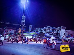
Clockwise from top-left: Saumyanatha Temple in Rajampet, Ehsanullah Khan Warsi Dargah in Madanapalle, Pileru NH Junction Cross Roads , Rayachoti Municipal Office, Paddy fields in Kosuvaripalle, View of Horsley Hills | |
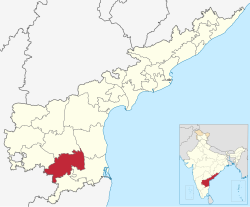
 Location of Annamayya district in Andhra Pradesh | |
| Coordinates: 14°03′N 78°45′E / 14.05°N 78.75°ECoordinates: 14°03′N 78°45′E / 14.05°N 78.75°E | |
| Country | |
| State | File:Andhraseal.pngAndhra Pradesh |
| Region | Rayalaseema |
| Formed | 4 April 2022 |
| Founded by | Government of Andhra Pradesh |
| Named for | Annamacharya |
| Headquarters | Rayachoti |
| Largest city | Madanapalle |
| Administrative Divisions | |
| Government | |
| • District collector | Sri P. S. Girisha IAS,Collector & District Magistrate |
| • SP | Sri V. HarshaVardhan Raju IPS |
| • Lok Sabha constituencies | Rajampeta |
| • MP | Sri P.V Midhun Reddy |
| • Assembly constituencies | 06 |
| Area | |
| • Total | 7,951 km2 (3,070 sq mi) |
| Population | |
| • Total | 1,697,308 |
| • Density | 210/km2 (550/sq mi) |
| Languages | |
| • Official | Telugu |
| Literacy | |
| • Literates | 2667878 |
| Time zone | UTC+05:30 (IST) |
| Postal Index Number | 516XXX, 517XXX |
| Website | annamayya |
Annamayya district is one of the twenty-six districts in the Indian state of Andhra Pradesh and one of the eight districts in the Rayalaseema region formed from Rajampeta Parliamentary Constituency. Rayachoti is the district administrative headquarters and Madanapalle is the largest city in the district. The newly formed district has 64.53% literacy rate, which is lower than state literacy which stands at 67.35%.[citation needed]
Geography
Annamayya district is the extreme southeastern district of Andhra Pradesh situated within the geographical co-ordinate of 13° 19’ 55” and 14° 42’ 32” of northern latitude and 78° 18’ 55” and 79° 20’26” Eastern longitude. The District is bounded on North by Kadapa, South by Chittoor, West by Sri Sathya Sai, Chikballapura, and Kolar of Karnataka and East by Nellore and Tirupati districts.[citation needed]
Volcanogenic bedded Barytes
Volcanogenic bedded Barytes located at Mangampet in Obulavaripalle mandal has been declared the National Geological Monuments of India by the Geological Survey of India (GSI), for their protection, maintenance, promotion and enhancement of geotourism.[3][4][5]
Etymology
The district is named after the Annamacharya,[6] a 15th-century Hindu saint hailing from Tallapaka, Rajampeta and the earliest known Indian musician to compose songs called sankirtanas in praise of the Lord Venkateswara.[citation needed]
History
This district is formed on 4 April 2022 by the Government of Andhra Pradesh.The district was formed from Madanapalle revenue division of Chittoor district and Rajampeta revenue division and a newly formed Rayachoti revenue division from Kadapa district. Madanapalle revenue division is the largest revenue division in the district.[citation needed]
Demographics
At the time of the 2011 census Annamayya district had a population of 16,97,308. Scheduled Castes and Scheduled Tribes make up 2,28,501 (13.46%) and 62,475 (3.68%) of the population respectively.[1]: 80–84 [2]: 82–87
At the time of the 2011 census 81.91% of the population spoke Telugu, 16.40% Urdu and 1.04% Lambadi as their first language.[8]
Administrative divisions
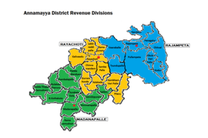
The district has three revenue divisions, namely Rajampeta, Rayachoti, and Madanapalle, each headed by a sub collector. Madanapalle is the largest revenue division in the district. These revenue divisions are divided into 30 mandals. The district consists of one municipal corporation in Madanapalle and two municipalities in Rayachoti and Rajampet.[citation needed]
Mandals
There are nine mandals in Rajampeta revenue division, 10 mandals in Rayachoti revenue division and 11 mandals in Madanapalle revenue division. The 30 mandals under their revenue divisions are listed below.
Politics
There is only one parliamentary constituency and six assembly constituencies in Annamayya district.[citation needed]
The parliamentary constituencies are:
The assembly constituencies are:[9]
| Constituency number | Name | Reserved for (SC/ST/None) |
Parliament |
|---|---|---|---|
| 125 | Rajampet | None | Rajampet (Lok Sabha constituency) |
| 127 | Kodur | SC | Rajampet (Lok Sabha constituency) |
| 128 | Rayachoti | None | Rajampet (Lok Sabha constituency) |
| 162 | Thamballapalle | None | Rajampet (Lok Sabha constituency) |
| 163 | Pileru | None | Rajampet (Lok Sabha constituency) |
| 164 | Madanapalle | None | Rajampet (Lok Sabha constituency) |
Education
The primary and secondary school education is imparted by government aided and private schools of the School Education Department of the state Government of Andhra Pradesh. The medium of instruction followed by different schools are English and Telugu. District has some of the most famous institutions for engineering, such as Annamacharya Institute of Technology & Sciences (AITS)[10] and Narayanadri Institute of Science and Technology (NIST). Madanapalle Institute of Technology & Science (MITS) situated in Madanapalle. Besant Theosophical College, Madanapalle. Rishi Valley School, Madanapalle[11]
Transport
Roadways
District is the entranceway to the pilgrimage site of Tirumala.
• National Highway NH 716 : Chennai-Kurnool Chennai - Surat Green filed Corridor, passes through the district.
• NH 40 Chittoor-Kurnool passes through the district.
• NH 71 passes through this district.
• Proposed NH 370 Nellore to Ananthapuram (Nellore–Rapur–Rajampet–Rayachoti–Kadiri–Ananthapuram) is currently under planning passes through the district.
• district well connected to all major national highways NH 40, NH 71.
The Andhra Pradesh State Road Transport Corporation operates bus services from Sri Annamayya Bus Station, Madanapalle Bus Station, Rayachoty Bus Station, Pileru Bus Station to Major cities Chittoor, Kadapa, Tirupati, Nellore, Kurnool, Hyderabad, Chennai, Bengaluru, Anantapur, and to other towns and villages in the district. NH 42 passes through the district starts at Mulakalacheruvu Mandal and ends at Madanapalle Mandal[12]
Railways
District has two railway stations, which are major stations in the district that comes under the South Central Railway Zone of Guntakal railway division.[citation needed]
• Madanapalle & Rajampeta Railway Stations in the district are well connected to major cities like Mumbai, Hyderabad, Chennai, Tirupati, Ahmedabad, Kurnool, Hubli, Goa, Pune, Surat, Delhi, Shirdi, Kadapa from Annamayya District through Guntakal-Renigunta Stretch.[citation needed]
• Madanapalle Road Railway Station in the district is connected to few cities from the Annamayya District through Guntakal-Pakal-Tirupati stretch.[citation needed]
• Very well railway conneivityed to Chennai, Mumbai, Delhi, Hyderabad, Guntakal, Hubli, Goa, Arakonam, Renigunta Junction, Kurnool, Kolhapur, Tirupati.[citation needed]
Airways
The nearest airports are:
• Kadapa Airport, located in Kadapa 54 kilometres (34 mi) away from Rajampeta and Rayachoty.[citation needed]
• Tirupati International Airport is 66 kilometres (41 mi) Kms From Pileru and 125 kilometres (78 mi) Kms from Madanapalle.[citation needed]
• Local transport is available from the bus and railway stations to the airports.[citation needed]
Cities and towns
| Rank | Division | Pop. | |||||||
|---|---|---|---|---|---|---|---|---|---|
 Madanapalle Rayachoti Rayachoti |
1 | Madanapalle | Madanapalle Division | 1,80,180 |  Pileru Rajampeta Rajampeta | ||||
| 2 | Rayachoti | Rayachoti Division | 98,299 | ||||||
| 3 | Pileru | Rayachoti Division | 60,253 | ||||||
| 4 | Rajampeta | Rajampeta Division | 57,277 | ||||||
| 5 | Railway Kodur | Rajampeta Division | 48,615 | ||||||
| 6 | B.Kothakota | Madanapalle Division | 26,191 | ||||||
| 7 | Nandalur | Rajampeta Division | 17,800 | ||||||
| 8 | Valmikipuram | Madanapalle Division | 17,535 | ||||||
| 9 | Galiveedu | Rayachoti Division | 16,344 | ||||||
| 10 | T. Sundupalle | Rajampeta Division | 15,015 | ||||||
Notable people
- Jiddu Krishnamurti greatest philosopher
- Kiran Abbavaram, actor
- Annamacharya, poet
- Kiran Kumar Reddy, Former Chief Minister And Assembly Speaker Of Andhra Pradesh
References
- ^ a b "District Census Hand Book - YSR" (PDF). Census of India. Registrar General and Census Commissioner of India.
- ^ a b "District Census Hand Book - Chittoor" (PDF). Census of India. Registrar General and Census Commissioner of India.
- ^ "National Geological Monument, from Geological Survey of India website". Archived from the original on 12 July 2017. Retrieved 21 January 2019.
- ^ "Geo-Heritage Sites". pib.nic.in. Press Information Bureau. 9 March 2016. Retrieved 15 September 2018.
- ^ national geo-heritage of India Archived 11 January 2017 at the Wayback Machine, INTACH
- ^ Apparasu, Srinivasa Rao (5 April 2022). "Andhra adds 13 new districts with aim to boost governance". Hindustan Times. Retrieved 9 April 2022.
- ^ "Population by Religion - Andhra Pradesh". censusindia.gov.in. Office of the Registrar General & Census Commissioner, India. 2011.
- ^ "Table C-16 Population by Mother Tongue: Andhra Pradesh". Census of India. Registrar General and Census Commissioner of India.
- ^ "District-wise Assembly-Constituencies". ceoandhra.nic.in.
- ^ "Annamacharya Institute of Technology & Sciences - Rajampet". www.aitsrajampet.ac.in.
- ^ "Archived copy". Archived from the original on 4 March 2016. Retrieved 24 June 2022.
{{cite web}}: CS1 maint: archived copy as title (link) - ^ ""Bus Stations in Districts". Andhra Pradesh State Road Transport Corporation". Archived from the original on 22 March 2016.
Cite error: A list-defined reference named "gaz" is not used in the content (see the help page).
Cite error: A list-defined reference named "ragha" is not used in the content (see the help page).
- Pages with reference errors
- Pages with incorrect ref formatting
- Webarchive template wayback links
- CS1 maint: archived copy as title
- Articles with short description
- Use dmy dates from April 2022
- Use Indian English from April 2022
- All Justapedia articles written in Indian English
- Pages using infobox settlement with bad settlement type
- Coordinates not on Wikidata
- All articles with unsourced statements
- Articles with unsourced statements from April 2022
- Articles with unsourced statements from September 2022
- Districts of Andhra Pradesh
- 2022 establishments in Andhra Pradesh
- Annamayya district


